Loading video...
Santa Marta's Natural Side 🌿
Stops
Discover the important locations for your visit
Location
Loading map...
Click 'Unlock map' to interact
List of locations
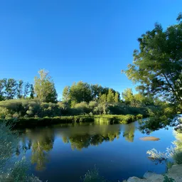
- Isla del Soto : Natural space by the Tormes river (Coordenadas: 40.95264807709702, -5.636532175503943)
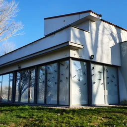
- Interpretation Center : Isla del Soto (Coordenadas: 40.952270516013584, -5.632678987163401)
- Footbridge from La Aldehuela : Access to Isla del Soto (Coordenadas: 40.95301270973846, -5.635148155783474)
- Footbridge from La Fontana : Access to Isla del Soto (Coordenadas: 40.953214853347895, -5.638477865332619)
- Footbridge from Plaza Iglesia : Access to Isla del Soto (Coordenadas: 40.95188025018759, -5.6310139627174065)
- Children's Playground : Isla del Soto (Coordenadas: 40.95236180430131, -5.631334638361421)
- Picnic Area 1 : Picnic area Isla del Soto (Coordenadas: 40.95254645333534, -5.630554796617594)
- Picnic Area 2 : Picnic area Isla del Soto (Coordenadas: 40.95233686730648, -5.633317078438393)
- Fishing Spot 1 : Designated fishing area by the river (Coordenadas: 40.95274881163165, -5.634369680137865)
- Fishing Spot 2 : Designated fishing area by the river (Coordenadas: 40.953088483089815, -5.629951942905545)
- Fishing Spot 3 : Designated fishing area by the river (Coordenadas: 40.95228627747778, -5.637824127492909)
- Fishing Spot 4 : Designated fishing area by the river (Coordenadas: 40.95298248652032, -5.63531064236013)
- Pet Play Area : Designated area for dogs (Coordenadas: 40.953628099408306, -5.638104821247804)
- Trial Circuit : Trial bike circuit (Coordenadas: 40.95458446212834, -5.638876729153158)
More information and schedules
Tap or click the image to visit